

By Glen Sorenson
Look at that
Part I: The Nemadji River tells its story
Hello, everyone in the Pine Knot community, hope you all had a great Thanksgiving. I did! I spent time with my family, my favorite mother-in-law and some of my grandkids. We always like to take a little hike in the woods and look for stuff; this time we ventured a little way out on a frozen pond and enjoyed looking through the ice and crystal clear water for plants, animals and whatever else we could discover. This got me thinking about the color of water in my own neighborhood. In Carlton County, we have the crystal clear water of Chub Lake, the root beer color of the St. Louis River, and the clay red of the Nemadji River.
Each body of water tells an interesting story; the variety of colors are indirectly due to earthly events that took place many thousands (even millions) of years ago. I decided to visit the Nemadji River story first. The Nemadji drains more than a third of Carlton County, mainly the central east and southeast portion. The river then runs through Douglas County in Wisconsin and empties into the St. Louis River at the Superior entry of Park Point. The word Nemadji has Ojibwe roots, meaning "river on the left side." Before the canal was dug on Park Point in Duluth, the only way to enter the St. Louis River from Lake Superior was through the Superior entry, the natural exit point for the river. As you enter the St. Louis Bay from the lake, paddle right to the St. Louis or take a left, and you will see the Nemadji River, hence the name.

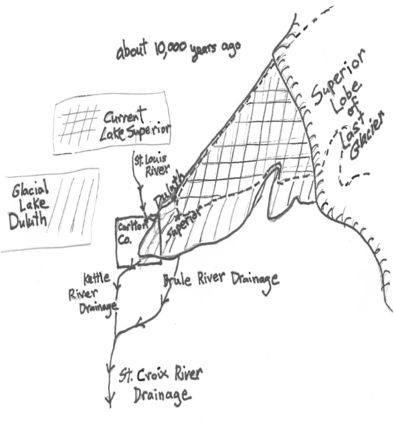
After a major rain or wind event in the area, the waters of the Nemadji pour tons (120,000 tons annually) of red clay into Lake Superior through the Superior entry; this is easily visible from Duluth. In my last two stories, I rode my science time machine back two billion and one billion years ago to check out the quartz and slate formation in the Thomson and Carlton areas. This trip I will go back only 10,000 years. I will need to dress warmly, as glacial ice is covering much of northern Minnesota. I stand on the site of the Thompson overlook near Spirit Mountain, and I see a totally different world. As I look to the south and east, I do see Lake Superior in its familiar spot with a few changes. To the west and south, where I would normally see Morgan Park and all the communities of west Duluth below, I see only water and even icebergs. In fact, my feet are on the new shoreline of the lake, and I am at the level of what would become Skyline Drive. Wow. This is not Lake Superior anymore. Scientists have named it Glacial Lake Duluth, 450 feet higher than it is today, so high that it spills to the south into Carlton County and heads to the St. Croix River via the Kettle. Why doesn't the lake drain to the Atlantic like it does today? As I look to the east, I see a huge wall of ice crossing the lake; the glacier has become a dam as it is melting and breaking up towards the east and north; the lake is so high that it also overflows the Wisconsin Brule and is flowing backwards into the St. Croix also.
I have run out of time to explore the red clay waters of the Nemadji River. We had to see Glacial Lake Duluth to understand the Nemadji, so we will finish the story next week. If I ever return to Glacial Lake Duluth I will bring my fishing pole - I bet the lake trout were huge.
FDLTCC science tutor Glen Sorenson was Minnesota Teacher of the Year before he retired from teaching science at Proctor High School after 30-plus years. He is an avid outdoorsman who most recently coached the Lumberjacks Nordic ski team.