Sudden 70s strike snowpack, leading to flooding worries
Contributed
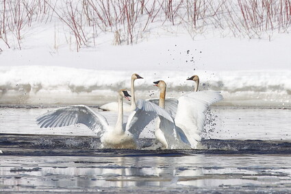
Will Stenberg captured these dancing swans along the St. Louis River in Chambers Park, east of Jay Cooke State Park, where the river broke open earlier this week as temperatures soared in the region. The sudden spring means residents need to be alert about flooding, especially this weekend as rain mixes with snowmelt.
One could easily mistake a northeastern Minnesota meteorologist for a sadist these days. Just two days after the messy April 4-5 snowstorm, followed by some slight signs of an actual spring, the National Weather Service in Duluth issued a report on the likely flooding that will occur in the region. It seems the winter of 2022-23 just won't relinquish its hold on the public conversation during a non-existent spring that had any children on an outdoor Easter egg hunt tromping over snow deeper than they were tall.
Meteorologist Ketzel Levins summed things up this way on April 6: If you've had flood problems in the past, "you'll see it again."
She called it an "extreme" snowpack that remained on the ground last week, waiting for this week of daily temperatures climbing into the 70s with temps above freezing overnight. That's a recipe for rapid snowmelt, bringing places like the St. Louis River in Scanlon near the flood stage. Any factors added to the mix, like the rainfall expected this weekend, will only hasten "active flooding," Levins said in her summary.
She said that if the snowpack melted in 14 days, from the time of her report to April 20, it would be the equivalent of a half-inch of rain each day as the deep snowpack held a "water equivalent" of 7 to 8 inches in Carlton County. There is some relief, she said, because much of the frost is out of the ground, allowing some of the melt and rain to soak into soil instead of running to rivers, lakes and low ground.
Marlyn Halvorson, Carlton County's emergency management director, was keeping close tabs on water levels. As of Wednesday, there were three reports of water over roadways and more expected. Crews go out and remove snow piled along roads and clear out any clogged culverts. They will also put up barriers or warnings and let emergency crews know of any hazards to watch for when out on calls.
"We plan for the worst-case scenario," Halvorson said. That means he is working with a host of county departments on what they would do in a massive flooding situation. Of particular interest each year is the business area in Scanlon along the St. Louis River and Moose Lake.
Halvorson said the rain expected this weekend will likely increase responses around the county as the snowpack continues to melt away. The county monitors flooding by looking at elevations across the landscape, he said.
Only four times since 1948 has the snowpack been this deep into April, Levins said. The region had a top-five annual snowfall for the season with an unusual water equivalent rate, leading to the "much above normal" prospects for flooding. Levins called it a "potent snowpack."
The weather service expected the St. Louis River to reach above 10.5 feet by Saturday, meaning it would be between the status of "minor" and "moderate" flooding. Waterways south of Cloquet are expected to have higher levels.
There are several factors aside from sudden high temperatures that will affect the flooding forecast, Levins said. Sunshine, higher dew points and higher wind speed will speed up the melt. Overnight temperatures above freezing mean 24-hour melting, she said. The rain expected this weekend will fall on what is called "ripe" snow that will easily melt and join the rainwater.
"We're playing the waiting game," Carlton County's Halvorson said. He said the quick turn to temperatures in the 60s and 70s is OK but the nights need to be cooler to slow the melt.
The forecast for the days past this weekend is trending toward normal temperatures in the 40s and 50s. While that could stabilize things, any rain "won't help" the flood prospects, Levins said. The water levels are at a tipping point with the melt. Rain, she said, "could lead to a pretty quick flood."
So, how fast was the snow melting this week? The Western Lake Superior Sanitary District on Wednesday reported that its storage basins were filling up in several locations with overflows a possibility. Water flow to the facility in Duluth was exceeding 120 million gallons per day compared to the average daily flow of 38 million gallons.
Residents in Proctor were asked to conserve water by late Tuesday as the city's sanitary sewer system was filling with meltwater. Residents were asked to not put extra pressure on the system.
UPDATE: Thursday, April 13
According to a warning shared by the Cloquet Police Department, at 12:19 p.m. Thursday, emergency management reported flooding in low-lying areas of the city of Moose Lake and Barnum City Park. Flooding is already occurring. - Flooding is occurring along the Moose Horn River and Kettle River.
Some locations that will experience flooding include... Cloquet, Moose Lake, Barnum, Mahtowa, Willow River, Cromwell, Rutledge, Kettle River, Fond du Lac Band Sawyer Area, Fond du Lac Band Cloquet Area, Big Lake, Sturgeon Lake, Automba, Denham, Kettle Lake, Moose Lake State Park, Ronald and Sawyer. - Flood safety information can be found at http://www.weather.gov/safety/flood.

Jana Peterson
Cloquet's Aaron Clark attacks the iceberg outside his home Tuesday on Sixth Street instead of going to the gym, he said, when the high temperature climbed into the mid-60s. He was helping the sun melt the large snowbank that is in the shade and melts more slowly than he'd like. "I love it. We've been waiting too long for these temperatures," he said. "Second week of April - that's way overdue."
A flood warning extends through Saturday afternoon for portions of east central Minnesota, Aitkin, Carlton and Pine Counties, including low-lying areas of the city of Moose Lake and Barnum City Park.
Instructions if you encounter flooded roadways:
Turn around, don't drown when encountering flooded roads. Most flood deaths occur in vehicles. Report observed flooding to local emergency services or law enforcement and to the National Weather Service in Duluth when you can do so safely. Flooding can be reported to the National Weather Service at 1-800-685-8612.
NOTICE OF EMERGENCY Carlton County BOARD OF COMMISSIONERS MEETING:
Notice is hereby given that the Carlton County Board of Commissioners will be holding an Emergency Meeting regarding Flooding at 3 pm today, Thursday April 13, 2023 at the Carlton County Transportation Building, 1630 County Road 61, Carlton.