

We can all help the watersheds
For much of the history of this country, rivers, lakes and waterways served as our sewers. That is until the Cuyahoga River in Ohio caught fire for the 13th time in 1969. This prompted the passage of the Clean Water Act in 1972 and launched programs nationwide to clean up our surface waters. Under the direction of the Environmental Protection Agency, national standards regulating pollutants and the restoration and monitoring of all surface water began.
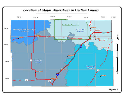
However, as the understanding of water pollution increased, the realization of the impact of watersheds on water quality evolved. Since 2013 the Minnesota Pollution Control Agency has focused on watersheds defined as, “an area of land where all the water that drains off of it goes into the same place-a river, stream or lake.” The agency has identified 80 major watersheds in the state.
Watersheds do not follow boundaries as defined by governmental surveys. Rather, rain or snow melt flows downward according to the geological structure of the land. Some precipitation will soak into the ground and seep into the aquifers, but excess water will drain into the watersheds. Soil erosion and pollutants, such as pesticides, oil and fertilizers, create the greatest threat to our surface water.
In a recent interview, Alyssa Bloss, certified conservation specialist with the Carlton County Soil and Water Conservation District said Carlton County is unique, because it contains four watersheds: the Nemadji River, St. Louis River, Kettle River and Upper Mississippi-Grand Rapids watersheds.
Bloss explained how the topography surrounding the Nemadji River continues to impact that watershed. The land is very hilly. The clay soil doesn’t absorb much water in heavy rain or rapid snowmelt. There are not enough water basins to slow down the flow of water in that area. “Actually, the Nemadji River is the biggest contributor of sediment of all the rivers that go into Lake Superior,” Bloss said.
One Watershed-One Plan is a program designed to bring various environmental agencies and groups together to determine how to use grant money “to help either enhance, restore and protect the natural resources,” Bloss said. “Right now, we’ve got a bunch of money for the Nemadji. We’re doing livestock pipelines, feedlot improvements, cover crops, pollinator projects.”
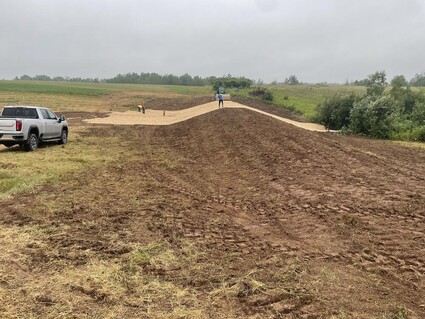
Janaki Fisher-Merritt, owner of the Food Farm, described how he contacted Bloss at the SCWD to help mitigate an erosion issue in a field he bought in 2014. The land is in the Nemadji River watershed. It had a deep gully with straight banks and had problems that were too severe to fix without help.
“I just called Soil and Water and said, ‘Hey, is there any assistance for this sort of thing?’” Fisher-Merritt said.
There was federal grant money to cover 90 percent of the cost.
A “water and sediment containment basin” was designed to slow the run-off during heavy rain and snowmelt events. It is an earthen dam about eight feet high with added components that hold back sediment and rainwater and gradually release them into the environment.
“It’s not meant to hold water indefinitely. It’s meant to calculate the peak flows we have here — fast snowmelt or a big rainstorm — and then let that water out slowly, so it’s empty by the time we get another big storm,” Fisher-Merritt said.
Fisher-Merritt described how the management of his land and crops impact the watershed as well. He has drain tiles in the fields because the water table is so high on his land. The tiles help to keep the field from saturation, which in turn encourages root growth in the plants. Deeper roots lead to better infiltration of rainwater, thus decreasing run-off. In addition, water that goes through the drain tile is caught in the irrigation pond and used during dry stretches.
One more practice that Fisher-Merritt employs on the farm is cover crops.
“Any time you have bare soil, you’re exposing the soil to wind erosion, water erosion, and nutrient loss,” he said.
Bloss noted the project completed on Fisher-Merritt’s farm will capture 8.14 tons of soil, 34 tons of sediment and 17.97 lbs. of phosphorus.
We can all do our part to protect our surface waters. Whatever choices we make will impact not only our property, but all the rest of the watershed.
“Anything you do on the landscape affects the watershed,” Bloss said. “Putting in a rain garden, catching that little bit of stormwater coming off your roof, your sidewalk and filtering that water before it hits our groundwater for our lakes and streams. That makes a big difference. Not using pesticides, fertilizers on just a little bit of your lawn. If everybody does just a little bit, it all accumulates.”
Writer Francy Chammings is a retired English teacher and clinical psychologist who loves living in Carlton County.